
The Marine highway system is in the forefront of alternate transportation concepts considered for meeting future freight capacity requirements. Moving freight by waterways reduces the impact of highway freight on the environment, saves transportation related fuel consumption, and reduces infrastructure maintenance cost, specifically on pavements and bridges. The system has the potential for complementing and increasing the productivity and performance of other intermodal systems.
A flexible modeling process was developed for analyzing diversion of freight from highways to waterways, interlinking results from the highway diversion model with a scalable waterway (marine) model. The results enable estimation of the cost and other advantages of the marine highway system. The quantification of direct and indirect benefits will guide the initial decision making process for planning marine highway. The model is constructed to be flexible and scalable for application to any waterway and highway system for rapid comparisons of advantages to support first line decision making.
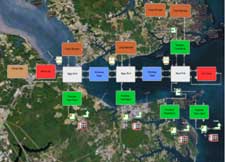
The project developed methods to compare potential cost savings in marine highways by coupling the following three modeling and analysis processes:
- A highway model for freight flow leading to the ports
- A waterway model for marine transportation
- A drayage freight flow analysis system.
The marine highway freight system (MHFS) offers the opportunity for increasing freight capacity and relieving highway congestion with low infrastructure investments. The GMU Consortium study showed that planning of marine highways can be accomplished cost effectively using results of model analysis and by applying emerging CRS&SI tools.